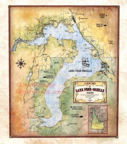

068-Lake Pend Oreille, Idaho Custom Map Designed By Lisa Middleton, Antique Map Print
Product ID: 32892426
Desertcart purchases this item on your behalf and handles shipping, customs, and support to Seychelles.
Lake Pend Oreille is the largest lake in the northern Idaho panhandle.The lake is surrounded by three mountain ranges, the Couer Alenes in the south,the Cabinet Mountains in the North,the Green Monarchs to the east and the Selkirk Mountains to the north and west. This places the lake at the southern end of the Purcell Trench.The lake itself was formed by a glacier moving and melting southward from Canada through the trench.The path of the Missoula Flood, a calamitous ancient flood, is believed to have passed through the area from the easternmost point of the lake which had massive geological effects on the region. The lake is now fed by Clark Fork River and the Pack River and drains via the Pend Oreille River which runs into Washington State. Canadian fur trader and explorer David Thompson founded a trading post in what is present day Hope,Idaho for the North West Company on the lake in 1809.As the lake? shape resembled a human ear,he referred to it as Pend Oreille,a French phrase for a pendant or jewelry that is hung from an ear.The trading post was called the Kullyspell House which was Thompson? spelling of the resident tribe. The Kalispel, now often referred to as Pend Oreille, are thought to have migrated south from British Columbia. The lake has had an interesting role American history.It was once a main part of the route for those seeking fame in the gold rush in the late 1800s. During the second World War, it was the home of a naval testing site for submarines due to its depth. It is still used by the Navy for some acoustic testing. The lake and its surrounding rivers also contributes as a source of electricity to the area. In 1952, the Cabinet Gorge Dam was built on the Clark Fork River and is privately owned. In 1955, the Army Corps of Engineers built the Albeni Falls Dam across the lake on the Pend Oreille River.The lake is now a tourist attraction for its beauty and fishing."
Trustpilot
3 weeks ago
4 days ago