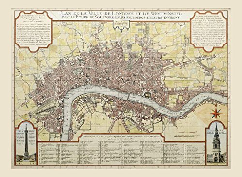
Description
- Large Detailed Reproduction Map of London by Guillaume Danet (76 x 58 cms) with two vignettes in the lower half (One of Monument and the Other of St Mary le Bow Church), of this 18th Century Plan fom Islington to Lambeth North / South and from Mile End to Hyde Park East / West Directions
- Two General Discriptions of London appear in the Top Right and Left Corners, both in the French Language
- Along the Bottom of the Map is recorded a list of Notable Streets, Churches, Hospitals and Places of Interest, with Their Grid Reference on the Map.
- Order before 3 pm for same day dispatch from our UK Warehouse. A Quality item that carries our 100% Guarantee of Satisfaction, or your money back.
Detailed Map of London with two vignettes in the lower half, of this 18th Century Plan fom Islington to Lambeth North / South and from Mile End to Hyde Park East / West. Two General Discriptions of London appear in the Top Right and Left Corners, both in the French Language. Along the Bottom of the Map is recorded a list of Notable Streets, Churches, Hospitals and Places of Interest with Their Grid Reference on the Map. Order before 3 pm for same day dispatch from our UK Warehouse. A Quality item that Carries our 100% Customer Satisfaction Guarantee, or your money back!