Description
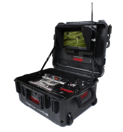
- Mission Control: The "Ground Station" unit is housed in a quality and robust SKB case and offers a variety of interface options - this self-powered unit can run additional monitors, provide USB charging, video control interfaces as well as its own Hi Resolution monitor and Remote control unit. Dimensions: 500 x 400 x 280 mm
- Industry: Cost effective, saving time and reducing risk to human lives - industrial applications are expanding for this technology and we are developing specialized craft for these; an ideal tool for mapping, planning and progress monitoring. Property developers can provide views from the 3rd, 4th, 10th floor of a building that does not even exist yet. Damage to property and the environment can be swiftly and accurately assessed after natural disasters; architects can create instant 3D images and imprints of subject areas and structures. Mining companies can gather volumetric data in just minutes; surveyors and construction companies can 3D map area's with relative ease; a power company can inspect lines and transformers, and carry leader lines across gulley's and ravines. This list grows daily.
- Media: From Hollywood blockbusters to wedding photography - aerial robotics is changing the way video and images are captured. Surreal sweeping shots, a true birds-eye view... Wildlife documentaries, commercials, news reports, advertisements and live broadcasts of sporting events are all enhanced by the new perspectives our systems offer. World renowned for advanced vibration dampening, payload capacity, transportability and durability, our systems have been the preferred choice for industry professionals for several years.
- Public Services: Easy to deploy, operate and retrieve, these systems are an essential resource to increase situational awareness, assess damage from natural disasters, search for missing bushwalkers, find hot spots in forest fires, sample air for pollution, map environments, inspect infrastructure, secure borders, report accidents and monitor environmental change. Infrared and Thermal Imaging cameras and various other equipment such as 3D LIDAR expand the functional value of these craft; the potential is limitless and we are ever expanding the scope of possibility.
- Agriculture: Scan your property with a birds-eye view to inspect infrastructure and stock - gathering crucial information for planning the day's activities. Remove the safety hazard of monitoring and mustering in rough terrain, save fuel, machinery costs and time simultaneously. Count stock instantly, accurately and remotely, recognize animals in distress. A number of agri-specific sensors are being developed for Precision Agriculture to monitor crop health, growth, irrigation, forecast yields, detect diseases at early stage and systems are even used to scare birds. Precision Spraying is under development for quick and precise crop and weed spraying, with greater safety for operator and environment. Forestry and fisheries are also opening to new possibilities that enable greater productivity.
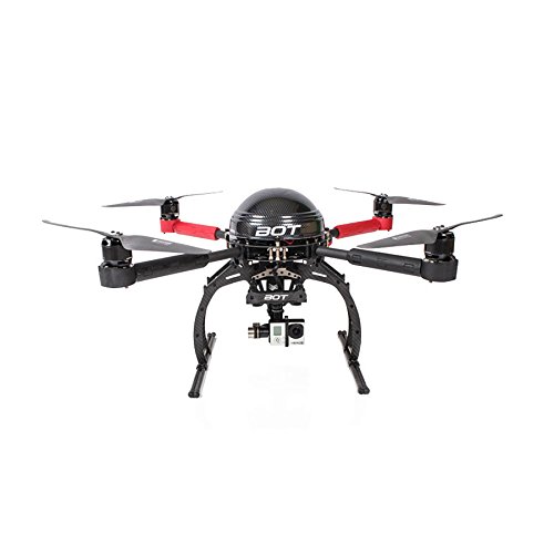
The Aeronavics BOT Compact Professional Quadcopter is a professional compact robotic craft designed for field applications such as farm inspection, sports filming and other uses in public services and light industries. It is robust and rugged, easy to use and fully supported. Camera Weight Class 0-500 grams ( 0-1Lbs ). Easy to Deploy Compact craft ideal for a quick birds eye view of the scene. Suitable for a journalist in the field, property Inspector, farmers and surveyor or to capture that adventure shot this craft is a serious little performer. Compact 670mm diameter. Comes with: Camera stabilizer, 2.4 Ghz Radio Remote, Mission Control Lite Remote, Industrial Upgrade for better flight time, Way point data link, Pelican Transport Case, Mission Control Ground Station, 1 Day flight training, Set of Carbon propellers, Thermal Imaging FLIR Camera, Field Repair kit, 2x LiPo 10000mAh Batteries. General Specifications: 1. Modular setup - easy pack down for transport 2. Pelican Custom Travel Cases (optional) 3. Real-time streaming of onboard video to mission control ground stations • GPS coordination and waypoint programming (various degrees) 4. Various fail safes including 'auto-leveling', 'position hold', 'return to base', 'auto-land on low battery' and controller-redundancy (non-standard) 5. Battery powered (LiPo) 6. Operational wind speed for autonomous flight up to 40km/h 7. Range of 3km (extendable up to 25km) 8. Speed up to 80km/h 9. Height ceiling of 400ft AGL (regulation enforced) 10. Four hours support included 11. Payload Capacity - 1.2Kg 12. Flight Endurance - 25 min. standard, up to 40 min. industrial 13. MTOW - 5Kg 14. Diameter - 631mm 15. Pack-Down Dimensions - 608 x 105mm 16. Payload/Ground Dimensions - 160mm